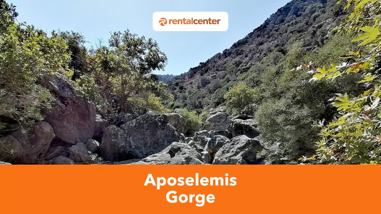
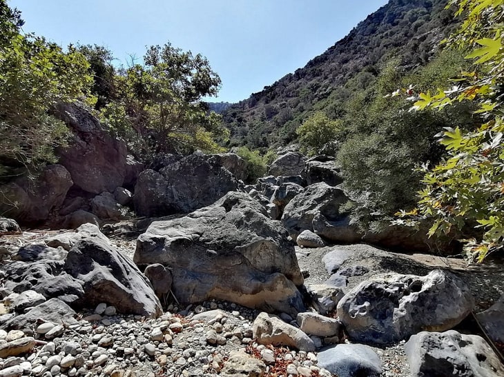
Aposelemis Gorge is the longest gorge in northern Heraklion, located near Analipsi, Agriana, and Kato Gouves in eastern Crete. The gorge stretches 6 kilometers (3.73 miles) to 1 kilometers (6.21 miles), with vertical walls reaching 0.2 kilometers (0.12 miles) and an elevation change of 100 meters. The Aposelemis River, which flows after rainfall, has shaped the gorge over time. Hikers follow trails that pass ancient stone bridges, Venetian arches, and wildlife habitats. The hike is rated easy to moderate and takes 2 to 4 hours.
Aposelemis Gorge is open year-round, though spring and autumn offer ideal conditions, with temperatures ranging from 24°C (75.2 °F) to 3°C (86 °F). Nearby attractions include Acqua Plus Water Park, Skotino Cave, Cretaquarium, and several beaches. A car rental provides the most convenient access to the gorge, with parking near trailheads. Public buses and organized tours are other options. Visitors describe Aposelemis Gorge as an enjoyable and scenic hike through one of the notable Crete gorges, with opportunities to observe birds of prey and diverse flora. The area features several nearby accommodations and local tavernas, making it an excellent day-trip destination or part of a longer Crete itinerary.
What is Aposelemis Gorge?
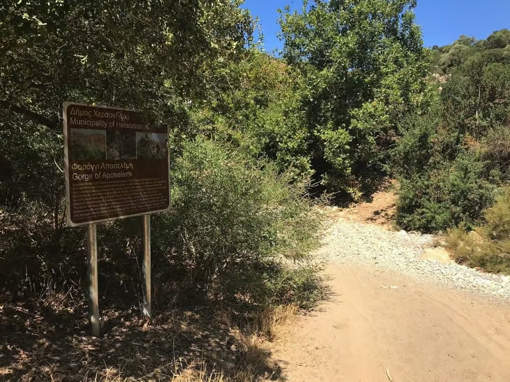
Aposelemis Gorge is the longest and most significant geological gorge in the northern part of Heraklion, a region in eastern Crete near the settlements of Analipsi, Agriana, and Kato Gouves. The gorge stretches 6 kilometers (3.73 miles) to 1 kilometers (6.21 miles), with an The elevation gain of Aposelemis is 315 feet (96.01 metres), while the elevation loss is 59 feet (17.98 metres). The maximum elevation of Aposelemis Gorge is 349 feet (106.38 m), while the minimum height is 89 feet (27.13 metres). The formation of Aposelemis Gorge resulted from erosion over time, with the Aposelemis River cutting through phyllite rock layers to create its steep vertical walls, which reach up to 0.2 kilometers (0.12 miles) in height. Historical evidence shows that shepherds once used the gorge to move livestock between mountains and valleys. Ancient stone bridges, Venetian arches, pottery fragments, and carved footholds remain visible along the path. The gorge’s name, derived from the Arabic “Abou Selim”, likely dates to the Arab occupation of Crete.

Aposelemis Gorge has panoramic scenery, lush vegetation and is rich in flora and fauna. There is a complex close to Aposelemis Gorge, called Kalamafka. Kalamafka is located 0.6 kilometers (0.37 miles) over the Aposelemis river bed. It is an inaccessible ridge that hangs high up on the east slope of the Aposelemis Gorge. There are scattered pottery sherds located in the paths on Kalamafka, which indicate that the path was ancient. In addition, there are footholds that are carved in the relic to guide the ascent to the area.
Aposelemis Gorge is preserved through local conservation efforts and is listed in the Corine Biotopes as an important natural site. Municipal investments maintain the trails and recreation areas to promote safe hiking. Aposelemis Gorge makes a significant contribution to Crete’s tourism, attracting hikers, nature enthusiasts, and birdwatchers to its accessible trails and rich ecosystem.
How difficult is hiking in Aposelemis Gorge?
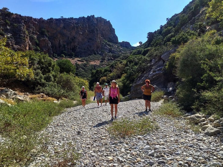
The difficulty of hiking in Aposelemis Gorge is rated easy to moderate, a level suitable for families, couples, and elderly hikers with reasonable fitness. The main trail covers a distance of 6 kilometers (3.73 miles) to 1 kilometers (6.21 miles), with an estimated hiking time. of 2 to 4 hours. The path follows a well-maintained route, with recreation and rest areas, wooden benches, and clear signage. Some climbing and scrambling sections are present, which may pose minor risks after rainfall when water collects in the riverbed. Proper footwear and caution are essential, especially during the wet season. A guide is not required to complete the hike, but guided tours are available for tourists who prefer organized excursions. Fit hikers can easily manage the trail without assistance. The route accommodates children, provided they are supervised and prepared for short climbs. Couples and seniors often choose the gorge for a manageable day hike with natural and historical interest.

There are a lot of risks and possibilities like medical circumstances such as strokes, cardiac arrest and illnesses. Exhaustion, hypothermia, dehydration and heat exhaustion. Injuries from slips and falls on the trail. Injuries due to animals, snakes and insects on the trail. Hikers getting trapped or injured by forces of nature such as flooding, veld fires and lightning. Injuries brought about by criminal attacks, assaults and robberies. There are quite a few mosquitos, so be wary of that. There are difficulties, and one needs to be aware that there is a lot of rock climbing. Aposelemis has some risks. The paths in the Gorge are rocky and steep, according to the people who visited Aposelemis Gorge. Hiking Aposelemis Gorge requires wearing good shoes. In addition, some of the paths have an unclear indication, which sometimes leads to confusion. They said that the path on the first half has markings with the use of ribbons, but the second half was a little more freestyle. The hike difficulty level of Aposelemis Gorge is easy to moderate. However, it is suggested to be physically fit before hiking the Gorge or make sure that there are no severe health issues.
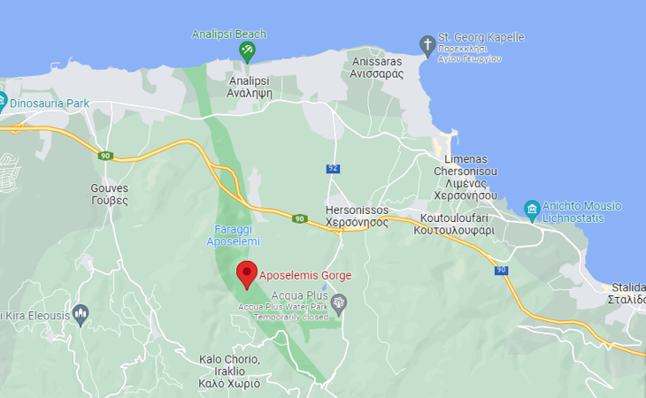
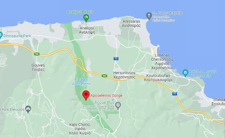
How does the Aposelemis Gorge map look?
The Aposelemis Gorge map outlines a linear hiking trail that begins near Xerokamares village and descends northward toward Agriana, ending near the mouth of the Aposelemis River at the sea. The mapped route measures 6 kilometers (3.73 miles) to 1 kilometers (6.21 miles), depending on the chosen path and entry point. Hikers encounter high vertical rock walls up to 200 meters, narrow valleys, and experience temperatures around 24°C (75.2 °F) and a mostly smooth riverbed, which occasionally holds water after rainfall. The map highlights key landmarks, including the old Venetian arch bridge, remnants of ancient stone paths, the abandoned village of Plevris, and carved footholds in the rock. Marked recreation and rest areas with wooden benches appear at both ends of the trail. The map does not indicate permanent water sources along the route, as the river flows intermittently. Emergency contact information and access points are generally noted at trailheads. The topography features gradual elevation changes of around 100 meters, with occasional steeper sections that require careful footing.
Find below an image describing the map of Aposelemis Gorge.
What are the hiking routes for Aposelemis Gorge?
Find below a list of several hiking routes for Aposelemis Gorge:
- Xerokamares to Agriana. The primary hiking route through Aposelemis Gorge begins near Xerokamares village, located at the southern end of the gorge. This 1 kilometers (6.21 miles) trail descends northward, ending near Agriana and the Aposelemis River mouth. Hikers traverse a riverbed path flanked by vertical rock walls up to 0.2 kilometers (0.12 miles) high, with sections of narrow valleys. The route passes the old Venetian arch bridge and ancient shepherd paths, with occasional scrambles required in steeper areas. This hike in Crete generally takes 2 to 4 hours to complete.
- Old National Road Bridge to Agriana. An alternate route begins at the old national road bridge, accessible by a dirt road. This path passes beneath the new highway bridge and through the abandoned village of Plevris. The route follows a section of the riverbed and rejoins the main trail toward Agriana. Hikers encounter remnants of stone structures and carved footholds, with moderate terrain suitable for most hikers. This route typically takes 2 to 3 hours.
- Circular Route from Kato Gouves. A circular route starts from Kato Gouves, using a connecting path to reach the north entrance of Aposelemis Gorge. Hikers descend into the gorge and return via parallel dirt roads and trails that overlook the valley. The route includes views of the wetland near the river mouth, rest areas, and birdwatching points. The loop covers 8 kilometers (4.97 miles) to 1 kilometers (6.21 miles) and requires about 3 to 4 hours.
When is the best time to visit Aposelemis Gorge?
The best time to visit Aposelemis Gorge is from April to June and from September to October. Daytime temperatures range from 24°C (75.2 °F) to 3°C (86 °F) during these months, offering pleasant conditions for hiking. The gorge remains open year-round, but seasonal conditions affect the hiking experience. The gorge features lush vegetation, flowing sections of the river, and active birdlife in spring. Summer, from July to August, brings higher temperatures often exceeding 3°C (86 °F), which may make hiking less comfortable, especially midday.
Aposelemis Canyon trail remains accessible, though hikers should carry sufficient water. Autumn, particularly in September and October, offers cooler weather and reduced visitor numbers, making it a favorable time for exploration. The trail remains open in winter (November to March), but rainfall may cause water to collect in the riverbed, increasing trail difficulty. Hikers during winter months should use caution and check local conditions before setting out.
What are the things to bring when visiting Aposelemis Gorge?
Find below a list of several things to bring when visiting Aposelemis Gorge:
- Good walking shoes. Good walking shoes provide essential support and grip on the gorge’s rocky, uneven terrain. The trail includes riverbed sections, loose stones, and some mild scrambling. Footwear should offer ankle support and non-slip soles to reduce the risk of injury, especially after rainfall, when rocks may become slick.
- Weather-appropriate clothing. Weather-appropriate clothing protects against changing temperatures along the trail. Light and breathable fabrics keep hikers cool in spring and summer, while layering helps adjust to cooler temperatures in autumn and winter, particularly in shaded gorge sections. Long sleeves and trousers help protect against insects and minor scrapes from shrubs along narrow paths.
- Water. Carrying enough water is crucial, as the Aposelemis River does not flow year-round. No reliable drinking sources are present along the trail. Each hiker should bring at least 1.5 to 2 litersof water to stay hydrated, especially during warmer months when temperatures often exceed 24°C (75.2 °F).
- Snacks or a packed lunch. Snacks or a light packed lunch provide energy during the hike, which typically lasts between 2 to 4 hours. The trail lacks food vendors or rest stops offering refreshments. High-energy options such as nuts, fruit, or energy bars help maintain stamina, especially if the pace slows at more technical sections of the route.
- Sun protection. Sun protection is vital, as portions of the trail remain exposed. A wide-brimmed hat shields the face and neck, while sunglasses protect the eyes. Sunscreen prevents sunburn on exposed skin, particularly in spring and summer when UV levels are high. Applying sunscreen before the hike and reapplying as needed is recommended.
- First-aid kit. A small first-aid kit prepares hikers for minor incidents. Items such as adhesive bandages, antiseptic wipes, blister pads, and pain relievers address common trail injuries. The kit should fit easily in a backpack and be readily accessible. The trail is moderate, but unexpected slips or insect bites may still occur.
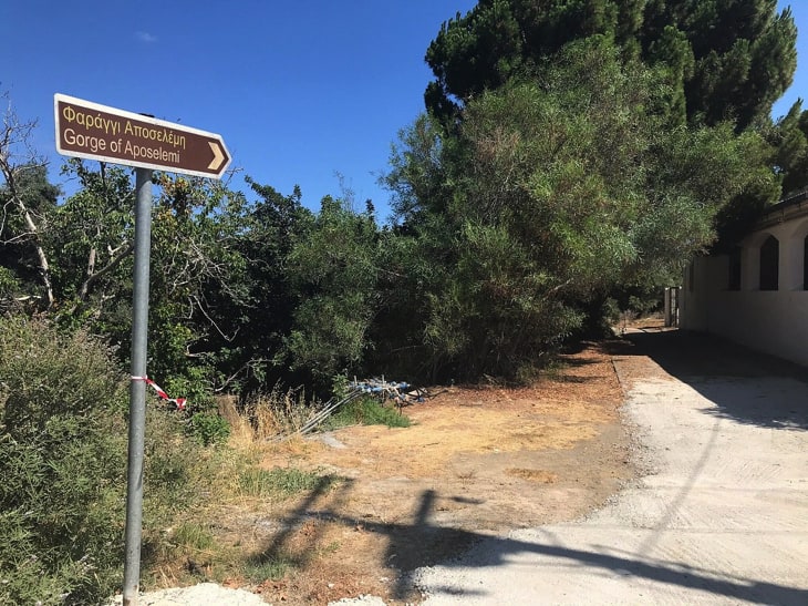
- Map or GPS. A printed trail map or a GPS device aids navigation. The main path is marked, but side paths and varying entry points can be confusing. A map or GPS ensures hikers stay on course, especially for self-guided treks. Checking the route in advance helps plan rest stops and estimate hiking time.
- Camera or binoculars. A camera or binoculars enhance the hiking experience. The gorge offers frequent sightings of birds of prey, including vultures, as well as a rich plant ecosystem. Capturing photographs or observing wildlife along the way adds interest to the hike.
What are the attractions to visit near Aposelemis Gorge?
Find below a list of the attractions to visit near Aposelemis Gorge:
- Acqua Plus. Acqua Plus is a sizable water park located 5.2 kilometers (3.23 miles) from Aposelemis Gorge. The park features a wide variety of water slides suited for all ages, along with a dedicated children’s area, an adventure playground, and a relaxing lazy river. The park serves as an enjoyable destination for families and groups looking to cool off after hiking the gorge. Its close proximity allows for an easy half-day combination of nature and recreation, especially during the warm summer months when the weather is at its most ideal for water adventures.
- Gouves Beach. Gouves Beach is a sandy shoreline located 10.9 kilometers (6.77 miles) from Aposelemis Gorge. The beach offers shallow waters ideal for swimming and wading. Umbrellas and sunbeds are available for rent, and beachfront tavernas provide fresh seafood and local dishes. Visitors enjoy walking along the promenade or exploring small shops nearby. Public parking and bus connections link the beach to surrounding villages and towns.
- Analipsi Beach. Analipsi Beach is located 14.3 kilometers (8.89 miles) from Aposelemis Gorge. The beach features a mix of sandy and pebbled areas, with clear waters that appeal to swimmers and snorkelers. Visitors find amenities such as cafes, tavernas, and small markets along the beachfront. The nearby village of Analipsi offers accommodations and local shops, making the beach a convenient place for an extended visit. Beachfront pathways encourage walking, and the beach is accessible by car with nearby parking available.
- Skotino Cave. Skotino Cave is an ancient cave located 11.5 kilometers (7.15 miles) from Aposelemis Gorge. The cave was historically used as a place of worship during the Minoan period, featuring large limestone formations and chambers of varying sizes. Archaeologists have uncovered numerous artifacts here, highlighting the cave’s religious significance. The site remains accessible year-round and offers an interesting historical stop after hiking the gorge.
- Dinosauria Park. Dinosauria Park is an educational attraction located 11.9 kilometers (7.39 miles) from Aposelemis Gorge. The park features life-sized dinosaur replicas, fossil exhibits, and 3D film screenings designed to engage visitors of all ages. Interactive displays explain prehistoric life and the evolution of dinosaurs. The park includes a café and gift shop, and seating areas are available throughout the grounds.
- Gouves Animal Shelter. Gouves Animal Shelter is located 12.6 kilometers (7.83 miles) from Aposelemis Gorge. The shelter serves as a rescue and rehabilitation center for abandoned and stray animals in the region. Visitors can tour the facility, volunteer, or offer donations. The shelter operates year-round, and information on adopting or sponsoring animals is available on-site.
- Cretaquarium Thalassokosmos. Cretaquarium Thalassokosmos is a modern aquarium located 13 kilometers (8.08 miles) from Aposelemis Gorge. The aquarium displays over 200 species of Mediterranean marine life, including sharks, rays, octopuses, and schools of colorful fish. Educational exhibits explain the ecology of the Mediterranean Sea. Visitors explore large viewing tanks, interactive exhibits, and themed sections. A café and gift shop are located on the premises, offering refreshments and souvenirs.
What are the transportation options to get to Aposelemis Gorge?
Find below a list of the transportation options to get to Aposelemis Gorge:
- By car rental from Heraklion. Driving from Heraklion to Aposelemis Gorge is a convenient option for independent travelers. The distance is 27 kilometers (16.78 miles), and the journey takes about 30 to 40 minutes via the VOAK (National Road) and local roads through Kato Gouves or Analipsi. Car rental in Heraklion is available through providers such as Rental Center Crete, allowing visitors to explore the region on their own schedule. Parking is available near the main trailheads, with access points from dirt or paved roads depending on the chosen entry.
- By public bus. KTEL buses operate regular routes between Heraklion and nearby towns such as Kato Gouves, Analipsi, and Hersonissos. From these towns, travelers can take a taxi or arrange local transport to the trailhead. This option is suitable for visitors without a car, though it may require additional planning for the last portion of the trip to reach the gorge itself. Timetables vary by season, and buses run more frequently in summer.
- By organized tours. Several tour operators based in Heraklion, Hersonissos, and the surrounding area offer guided hiking tours to Aposelemis Gorge. These packages typically include round-trip transport by minibus, a local hiking guide, and sometimes refreshments or packed lunches. Organized tours are ideal for visitors who prefer not to arrange their own transportation or who wish to learn about the gorge’s history and ecology during the hike. Tours operate seasonally, with more options available from April to October.

Can you rent a car to go to Aposelemis Gorge?
Yes, visitors can rent a car to go to Aposelemis Gorge. The drive from Heraklion to the gorge takes 30 to 40 minutes, covering a distance of about 27 kilometers (16.78 miles) via the VOAK (National Road) and local roads. The final approach includes paved and dirt roads, which are generally in good condition. A standard car is suitable for this route, though a vehicle with higher clearance may offer more comfort on the dirt sections. Parking spaces are available near the main trailheads, particularly at the northern exit, with access from the old national road bridge. Visitors should consider factors such as transmission type, fuel policy, and insurance coverage prior to booking a Crete car rental. Many rental companies offer both manual and automatic vehicles. It is advisable to check whether the rental company allows ferry transport if planning to combine the rental with visits to other islands or remote areas of Crete.

The cost of a car rental in Crete depends on the vehicle type, transmission, rental duration, and season. Rates for a small car range between €25 ($29.23, £21.68) and €40 ($46.77, £34.69) per day, with the lowest rates in winter and the highest in August. Hiring a large car costs between €44.7 ($52.27, £38.76)–€95.1 ($111.20, £82.47), while an SUV ranges from €67.8 ($79.28, £58.80)–€120.8 ($141.25, £104.76). Vans rentals cost between €66.2 ($77.41, £57.41)–€137.4 ($160.66, £119.15), and cabriolets range from €47.4 ($55.42, £41.11)–€109.3 ($127.80, £94.78). Peak prices occur in July and August. Off-season months such as January, February, and November offer the best car rental deals. Crete car hire rates typically include basic insurance and taxes. Automatic transmission vehicles may incur an additional daily charge. Factors such as fuel policy, mileage limits, and optional insurance coverage affect the final price. Travelers should compare rates across agencies and confirm all terms before agreeing to rent a vehicle.
Listed below are the factors to consider before renting a car in Crete.
- Insurance. Crete car rental includes insurance for Collision Damage waiver, and a credit or debit card under the driver’s name is required as a guarantee. Rental car insurance protects a passenger against the cost of damage when renting a car.
- Driver’s age. In Crete, the legal age needed for a car rental driver is 21 years old. A driving licence for at least a year, is also required.
- Driver’s gender. A driver at a legal age of 18 regardless of gender, is allowed to drive in Crete.
- Car type. Opting for a smaller car is best when driving in Crete. The main reason is that Greek roads are narrow. There are noticeably smaller cars on the streets too. However, there are other factors to consider and help How to Choose the Right Car to Rent in Crete. There are activities in Crete, such as off-road exploration, in which Four-Wheel Drive (4WD) is needed. 4WD is known for more rugged terrain and typically consists of low and high options.
- Documents needed for renting a car. Most people think the only necessary document for renting a car is a driving licence. However, a debit or credit card with the driver’s name must be provided, including a passport or an ID card.
What do visitors say about Aposelemis Gorge?
Visitors describe Aposelemis Gorge as an enjoyable and moderately adventurous hike through one of the notable Crete gorges. Many appreciate the clearly marked path, with red and white trail markings guiding the way, though a few mention that sections can be confusing, especially near construction zones related to the new airport. Hikers recommend wearing good walking shoes and bringing sufficient water, as no supplies are available along the trail. The landscape impresses visitors, with towering cliffs and vultures often seen circling overhead. Some hikers note the opportunity to spot wildlife, such as snakes, salamanders, and goats. Families with young children report positive experiences, with certain sections of the trail suitable for shorter walks. Drivers mention that gravel and dirt access roads may require careful navigation but are manageable with caution.
What are the places to stay overnight near Aposelemis Gorge?
Find below a list of the places to stay overnight near Aposelemis Gorge:
- Villa Stravorina. Villa Stravorina is a holiday apartment rental located 2.6 kilometers (1.62 miles) from Aposelemis Gorge. The property offers a peaceful retreat in a natural setting, with a modern design and a fully equipped interior. Guests enjoy a private swimming pool, a green garden, and panoramic views of the surrounding landscape. The villa includes all essential amenities for a comfortable stay, from a stocked kitchen to spacious living areas. Renting a car is necessary to access this secluded property, as the location offers privacy and tranquility away from the main tourist areas. Many guests describe the villa as an ideal place to relax after a day exploring the gorge and nearby attractions.
- Villa Kalo Chorio. Villa Kalo Chorio is a 3-star hotel located 3 kilometers (1.86 miles) from Aposelemis Gorge. The accommodation features stylish guest rooms with expansive views of the surrounding countryside. Each room offers modern comforts, while the kitchen facilities allow for self-catering. Guests frequently mention the exceptional hospitality of the host, Maria, who provides personal attention and local recommendations. The property’s location guarantees a quiet atmosphere, making it a popular choice for couples and families seeking a restful stay near the gorge.
- Villa Kokkalis Resort. Villa Kokkalis Resort is a 4-star hotel located 6.9 kilometers (4.29 miles) from Aposelemis Gorge. The resort offers spacious accommodations with well-appointed bedrooms, each featuring a private bathroom. The property comes with a fully equipped kitchen, large communal spaces, and outdoor areas designed for relaxation. Guests appreciate the hosts’ detailed recommendations for local dining and activities. The villa’s central location on Crete makes it a convenient base for exploring both Aposelemis Gorge and other destinations across the island.
What are the places to eat and drink near Aposelemis Gorge?
Find below a list of places to eat and drink near Aposelemis Gorge:
- Stou Kymona. Stou Kymona is a traditional taverna located 2.6 kilometers (1.62 miles) from Aposelemis Gorge. The restaurant offers an authentic village atmosphere, with colorful decor and a long-standing history of over 100 years as a local dining spot. Guests appreciate the friendly service, quality Greek cuisine, and reasonable prices. Popular dishes include village sausage and a variety of traditional specialties. The staff maintains close ties with the locals, enhancing the welcoming and genuine experience. Diners recommend Stou Kymona for its large portions, relaxed setting, and excellent value.
- Xerokamares. Xerokamares is a local taverna located 3.6 kilometers (2.24 miles) from Aposelemis Gorge. The restaurant serves homemade Cretan cuisine in a beautiful garden setting, shaded by a centuries-old carob tree. Visitors praise the quality and freshness of the food, with ingredients often sourced directly from the owner’s nearby garden. The menu features generous portions of traditional dishes such as grilled meats, local vegetables, and house-prepared olives. Guests frequently mention the personal touch of the experience, including complimentary fruit platters and the opportunity to observe the owner harvesting ingredients on-site.
- Taverna Maris. Taverna Maris is a welcoming restaurant located 5.2 kilometers (3.23 miles) from Aposelemis Gorge. The taverna offers outdoor seating with pleasant views, making it a comfortable stop after hiking. The menu highlights traditional Greek favorites such as souvlaki, fried zucchini, tzatziki, Greek salad, and slow-cooked lamb. Guests appreciate the freshly prepared dishes, attentive service, and reasonable prices. Unique offerings include stewed goat in wine sauce and warm beetroot salad. The taverna also sells local honey, spices, and olive oil, providing visitors with the opportunity to purchase authentic Cretan products. The casual atmosphere and spacious patio make this a favored dining option in the area.
Last updated on .