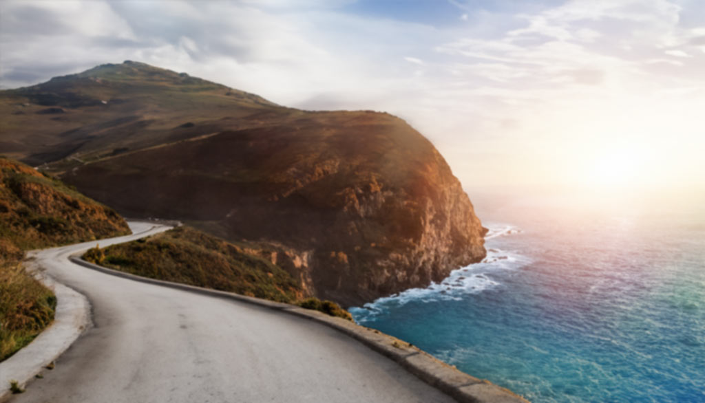
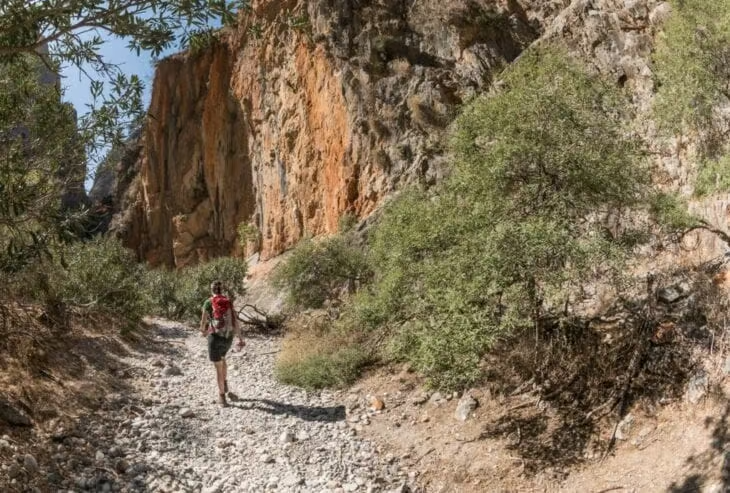
Aradena Gorge is one of Crete’s most dramatic Gorge natural landmarks, stretching 15 kilometres (9,32 miles) from the abandoned village of Aradena to the secluded Marmara Beach on the island’s southern coast. Aradena Canyon was formed through millennia of erosion and tectonic activity, and offers a challenging but rewarding hiking experience, featuring steep descents, narrow passages, and vertical drops aided by metal ladders.
Aradena gorge lies within a Natura 2000 conservation area, home to rich biodiversity including griffon vultures and endemic plants. Popular hiking routes range from direct descents to circular day hikes starting in Loutro or Anopoli, with all paths requiring stamina, proper footwear, and plenty of water. A detailed map highlights topographical changes and route difficulties, helping visitors plan their adventure. The best time to hike is in spring or autumn, when temperatures are moderate and trails are safer.
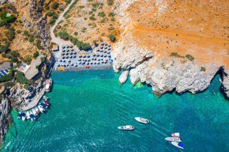
Visitors often end their trek at Marmara Beach, where a taverna and boat service await. Transportation options include rental cars from Chania or guided tours from major towns. Nearby villages offer guesthouses and coastal accommodations for visitors wanting to stay overnight. Tourists can also enjoy local tavernas and beach bars in Loutro, Livaniana, and Chora Sfakion. Aradena Gorge promises a memorable adventure in one of Crete’s most rugged and beautiful landscapes for both seasoned hikers and nature enthusiasts.
What is Aradena Gorge?
Aradena Gorge is a natural canyon in southwestern Crete, a geological formation that developed through water erosion and tectonic activity over thousands of years. Aradena Gorge stretches 15 kilometres (9,32 miles) from the southern slopes of the White Mountains to the Libyan Sea. Most visitors hike 6–7 kilometres (3,73–4,35 miles) from Aradena village to Marmara beach. Most visitors begin hiking at Aradena village instead of the gorge’s origin in the White Mountains, reducing the distance they experience.
The hike through Aradena Gorge takes 2.5 to 4 hours depending on pace and experience. Steep terrain and uneven ground require sure-footedness and increase difficulty compared to other gorges in Crete. A round trip covering between 15 and 18 kilometres (9,32 and 11,18 miles) from villages like Loutro or Anopolis takes up to 6 hours.
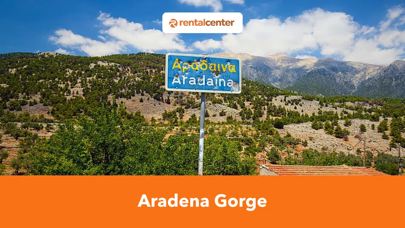
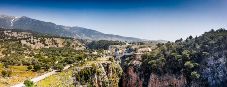
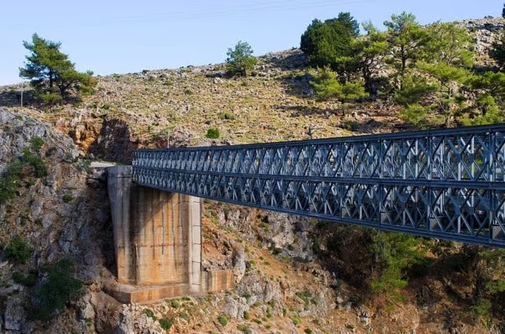
Aradena Gorge lies in southwest Crete’s Sfakia region. Aradena village stands abandoned on the gorge’s edge. Aradena was built on the ancient city of Aradin, founded by Phoenicians. The city flourished under Roman, Byzantine, and Venetian rule through trade using the coastal port of Loutro. The Church of the Archangel Michael contains 14th-century frescoes. Aradena was destroyed after the 1770 rebellion, during the 1821 war, and in 1867 during Turkish and Egyptian occupation. Population declined after World War II due to isolation and living conditions. A 1948 family feud forced the last residents to flee. The Vardinogiannis family funded a 138-meter bridge in 1986, connecting Aradena to Anopoli. The bridge enabled bungee jumping and limited revival. Descendants have begun restoring houses. Aradena remains mostly abandoned but shows signs of recovery as a historic mountain settlement.
Archaeologists have identified pottery fragments, burial sites, and building foundations in the region, a collection that reflects continuous habitation from classical to Byzantine times. Aradena Gorge is protected under Natura 2000, a European network of conservation sites that safeguard habitats and species of ecological importance. The gorge supports a range of flora and fauna, including griffon vultures and endemic plant species, a biodiversity that strengthens its conservation value. The area contributes to tourism in Crete as a popular hiking destination, a role that brings visitors to the nearby villages and coastal areas.
Aradena Gorge formed through tectonic activity and erosion over millions of years. Plate convergence between the African and Eurasian plates caused the uplift of Crete and shaped the White Mountains. The Aradena River eroded the rising landscape, carving through limestone. Limestone bedrock dissolved gradually through karst processes driven by acidic water, deepening the gorge. Geological forces remain active, and the gorge continues to evolve. Aradena Gorge provides direct evidence of long-term tectonic and erosional processes in a geologically complex region.
The best time to visit Aradena Gorge is between late April and early June or from mid-September to early November. These months offer moderate weather, clear trails, and safer hiking conditions. Daytime temperatures during spring and autumn range from 24°C-30°C (75°F-86°F), a climate that supports long hikes without excessive heat stress. Temperatures often exceed 35°C (95°F) during summer, a level that increases the risk of heat-related exhaustion, especially in the exposed sections of the gorge with minimal shade. Winter months are not ideal due to rainfall and possible rockfall hazards, as the trail runs along a dry riverbed that becomes unstable in wet conditions. Spring visitors often encounter wildflowers and active birdlife, while autumn hikers benefit from cooler temperatures and fewer crowds. Hikers should start early in the morning, especially during warmer months, to avoid peak midday temperatures.

Elderly individuals in good health and with moderate fitness may hike parts of Aradena Gorge, though the rugged and uneven terrain requires caution. Individuals with mobility issues or health conditions should remain at viewpoints or other accessible areas. Couples can hike Aradena Gorge together and share a physically engaging outdoor experience. The gorge is not suitable for young or inexperienced children due to safety risks. Families with older children who are confident hikers may attempt parts of the trail but should carefully assess the terrain and the children’s capabilities.
How difficult is hiking in Aradena Gorge?
Hiking in Aradena Gorge is moderately to highly difficult. The 15 kilometres (9,32 miles) route from the Aradena bridge to Marmara Beach includes uneven terrain, narrow rock passages, and steep descents. The trail features vertical drops with metal ladders and wooden planks, a layout that increases the risk of falls and injuries for inexperienced hikers. A guide is not required to complete the hike, although hiring one is possible through local providers in Anopoli or Chora Sfakion. Guides offer trail navigation and safety support, a service recommended for those unfamiliar with the area. The gorge is not suitable for elderly individuals with limited mobility due to its physical demands and lack of handrails. Couples in good physical condition often complete the trail without issue, especially if they bring adequate water and hiking shoes. The route is not child-friendly because of dangerous cliff edges, high summer temperatures, and technical climbing sections that require adult strength and coordination.
What do visitors say about Aradena Gorge?
Visitors describe Aradena Gorge as one of the most rewarding yet physically demanding gorge in Crete. Most reviews praise the Aradena for its dramatic cliffs, wildlife, and scenic hiking path leading to Marmara Beach. Many hikers appreciate the varied terrain, which includes metal ladders, rope-assisted descents, and rocky passages that require careful footwork. The hiking experience is often described as challenging but manageable for hikers in good health. Several trekkers note the peace and solitude, especially in off-season months like winter, and highlight the presence of eagles and vultures as a unique feature. The final stop at Marmara Beach receives consistent praise, particularly for its clear water, nearby restaurant, and access to taxi boats.
Visitors warn about the lack of shade along certain segments of the trail on the downside, particularly if diverted by unclear signs, such as the arrow pointing toward Taverna Livaniana, which has caused some hikers to take longer and hotter detours. Others report difficulty with specific sections of the trail, especially where ropes are needed to navigate rock faces. Several reviews caution against attempting the hike with small children or in peak summer months due to the heat and limited water sources. A few also point out the trail’s lack of clear signage in critical areas like the location of the ladders. Aradena Gorge is considered one of the most challenging Crete gorge to hike.
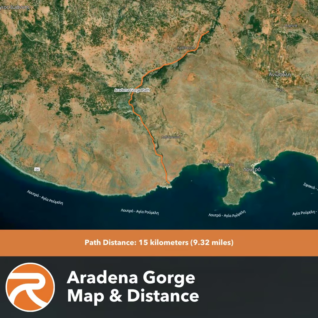
How does the Aradena Gorge map look?
The Aradena Gorge map outlines a trail from the abandoned village of Aradena to Marmara Beach on Crete’s southern coast. The path begins near the Aradena Bridge, descends through the gorge, and concludes at the beach. The map highlights key features such as steep descents, narrow passages, and metal ladders assisting in navigating vertical drops. Elevation changes are marked, showing a descent from about 600 meters (1,969 feet) near Aradena to sea level at Marmara Beach. Topographical details include the surrounding White Mountains and the proximity to nearby villages like Anopoli.
Find below an image describing the Aradena Gorge Map.

What are the hiking routes for Aradena Gorge?
Find below a list of the hiking routes for Aradena Gorge:
- Aradena to Marmara Beach (Direct Descent). The Aradena to Marmara Beach route is the most direct path through the gorge. The trail begins at the metal bridge of Aradena and continues for 7.5 kilometers (4.7 miles) toward the Libyan Sea. The hike takes roughly 2.5-3.5 hours, depending on pace and rest stops. The trail follows a dry riverbed, with sections of jagged limestone, boulders, and two vertical drops requiring the use of fixed metal ladders. The route passes under high cliffs where griffon vultures nest, and ends at Marmara Beach, where boat service to Loutro is available. This is a popular hike in Crete for adventurers seeking a full descent through a remote canyon.
- Loutro – Anopoli – Aradena – Marmara – Loutro (Circular Day Hike). The circular route starts in Loutro and leads hikers up a steep footpath toward Anopoli, continuing by road to Aradena village. The trail descends through Aradena Gorge to Marmara Beach before returning along the coastal path to Loutro. The entire route spans 18 kilometers (11.2 miles) and requires 6-8 hours to complete. The ascent to Anopoli is steep and exposed, making early starts advisable during summer. The descent through the gorge includes technical segments with ladders, while the coastal path back to Loutro includes minor elevation changes along rocky terrain. Hikers often stop at Marmara Beach for a swim or a short break before finishing the loop.
- Marmara Beach to Aradena (Reverse Gorge Hike). The reverse hike from Marmara Beach to Aradena involves climbing the same 7.5 kilometers (4.7 miles) as the standard descent but in the opposite direction. This route starts at sea level and ascends gradually through the gorge. The vertical ladders and rocky terrain are more challenging on the way up, particularly in hot conditions when temperatures reach 24°C to 30°C (75°F–86°F). This route is less frequented due to its difficulty and the effort required for the climb. Hikers usually reach Marmara Beach by boat from Loutro and begin the hike from the shoreline.
What are the things to bring when visiting Aradena Gorge?
Find below a list of things to bring when visiting Aradena Gorge:
- Sturdy hiking boots. Sturdy hiking boots support the ankles and provide traction on the rocky and uneven terrain throughout the gorge. The trail includes loose stones and long descents that increase the risk of slips for hikers wearing improper footwear.
- Backpack. A lightweight backpack allows hikers to carry essentials such as water, food, and personal items without adding unnecessary weight. A well-fitted pack with padded straps prevents shoulder strain during the 5 to 7-hour walk.
- Water. At least 2-3 liters of water per person is necessary, especially in warmer months when dehydration is a serious risk. There are a few water refill points along the trail, but it’s safer for trekkers to carry their own supply from the start.
- Food and snacks. High-energy snacks such as nuts, dried fruits, and sandwiches help maintain energy and prevent fatigue along the way. There are no food vendors inside the gorge, so hikers must be self-sufficient for the full duration.
- Sun protection. Sunscreen, a wide-brimmed hat, and sunglasses shield hikers from direct sunlight, particularly in exposed sections of the trail. Prolonged sun exposure can lead to sunburn or heat exhaustion, especially in summer.
- Map or GPS. A physical map or GPS app helps track position and identify landmarks even though the route is well marked. It helps to know progress along the trail in rare cases of fog or large crowds.
- First-aid kit. A basic first-aid kit should include blister pads, antiseptic wipes, bandages, and any personal medications. The trail is remote and rocky, so even small injuries can become problematic without basic treatment.
- Trekking poles. Trekking poles improve stability on descents and reduce stress on the knees, particularly in the early steep section from Xyloskalo. They are especially useful for hikers with joint issues or poor balance.
- Light jacket or layers. A light jacket or extra layer is useful for the early morning start when temperatures are cooler at higher altitudes. The weather warms quickly during the descent, so layers help manage comfort throughout the day.
- Swimsuit and towel. A swimsuit and towel are useful for those who want to swim at Agia Roumeli after the hike. The beach at the exit offers a refreshing end to the long walk, especially during hot weather.
What are the nearby attractions in Aradena Gorge?
Find below a list of the nearby attractions in Aradena Gorge:
- Marmara Beach. Marmara Beach is located at the southern exit of Aradena Gorge, a small rocky cove where hikers often conclude their descent. The beach is accessible only by footpath or boat, with clear waters and sea caves along the shoreline. A small tavern operates near the beach, serving refreshments and local dishes to visitors resting after the hike. Boats from Marmara offer transfers to Loutro and Chora Sfakion, making it a practical stop for hikers without return transport. Marmara beach is not organized with sunbeds or lifeguards, so visitors should bring their own supplies if they plan to stay.
- Anopoli Village. Anopoli Village is located 3.5 kilometers (2.17 miles) northwest of the Aradena bridge and serves as a common starting point for hikers arriving by car. The village sits on a plateau in the White Mountains and offers views of the gorge, the southern coast, and the Libyan Sea. Anopoli is known for its historical role in Cretan resistance movements, particularly as the birthplace of Daskalogiannis, a local leader who fought against Ottoman rule. The village has a few guesthouses, traditional tavernas, and a small square with a statue of Daskalogiannis. Visitors often stop here before or after hiking, especially if they choose the circular route through Aradena Gorge.
- Loutro Village. Loutro Village is located 5 kilometers (3.1 miles) southeast of the gorge’s exit and is reachable by coastal path or boat from Marmara Beach. The village has no road access, and transport is limited to small ferries or hiking trails. Loutro features whitewashed buildings, a quiet harbor, and a row of tavernas and cafes facing the sea. Small hotels and guesthouses provide accommodations for hikers staying overnight. Common things to do in Loutro are swimming and kayaking.
- Samaria Gorge. Samaria Gorge is located in Southwest Crete within the regional unit of Chania. The Samaria Gorge boasts a rich diversity of over 450 species of plants and animals, earning it the prestigious title of a World Biosphere Reserve.
- Agia Roumeli Beach. Agia Roumeli boasts a pebble beach and the refreshing waters of the Libyan Sea is located near the exit of Samaria Gorge. It is a popular stop for hikers completing the Samaria Gorge trek. The distance from Aradena Gorge to Agia Roumeli Beach is approximately 22.2 km (13.17 miles) and includes using a ferry.
- Sfakia. Sfakia is one of Crete’s most authentic and historically rich regions. It offers a glimpse into traditional Cretan culture and hospitality. The charming village features narrow streets, a small port and a friendly ambiance. The distance from Aradena Gorge to Sfakia is approximately 12.9 km (8 miles).
- Filaki Beach. Filaki Beach is a remote and unspoiled sandy beach with clear waters and stunning surroundings located west of Sfakia. It is a quiet spot ideal for those seeking tranquillity and seclusion. The distance from Aradena Gorge to Filaki Beach is approximately 15.7 kms (9.8 miles).
- Agios Pavlos Beach. Agios Pavlos Beach is a serene and less-visited beach with golden sands and clear waters situated on the southern coast of Crete. The unique rock formations add to the beauty of this tranquil spot. The distance to Agios Pavlos Beach from Aradena Gorge is approximately 71.9 km (44.6 miles).

What are the transportation options to get to Aradena Gorge?
Find below a list of the transportation options to get to Aradena Gorge:
- By car from Chora Sfakion. Driving from Chora Sfakion to Aradena Gorge is the most direct option for visitors with a rental vehicle. The route follows a winding mountain road through Anopoli and ends near the Aradena bridge, which marks the start of the gorge hike. The drive covers approximately 20 kilometers (12.4 miles) and takes around 45 minutes. Road conditions are generally good, but caution is required on sharp turns and narrow passages. Car hire in Chania is available through several providers, with travelers often driving south to Chora Sfakion before continuing toward Aradena. Chora Sfakion offers limited parking and serves as a convenient stop for food, supplies, or overnight stays before the hike.
- By boat and on foot. Visitors without a car can reach Aradena Gorge by combining boat and walking routes. Daily ferries connect Chora Sfakion with Loutro and Marmara Beach. Hikers can walk a coastal path to Marmara Beach from Loutro and enter the gorge from its southern end. This approach reverses the standard route and requires a return hike uphill or a pre-arranged pickup at the top. Boat services are weather-dependent and run more frequently during the summer months.
- By organized hiking tour. Guided hiking tours to Aradena Gorge operate from Chania, Rethymno, and Chora Sfakion. These tours include transport, a licensed guide, and return arrangements via boat or shuttle. Some tours begin in Anopoli, where vehicles drop participants near the gorge entrance and collect them later in Loutro or Chora Sfakion. This option suits visitors without private transport or those unfamiliar with the area.
Can you rent a car to go to Aradena Gorge?
Yes, visitors can rent a car to go to Aradena Gorge. The drive to the gorge involves a scenic route along coastal and mountain roads, with the final stretch passing through the village of Anopoli. Parking is available near the Aradena bridge, where a small dirt lot accommodates several vehicles. The space is unpaved and limited, so early arrival is recommended during peak season. Renting a car offers flexibility for independent travelers, allowing them to set their own schedule and explore nearby attractions without relying on boat or tour timetables. A small to mid-sized car with good ground clearance is recommended, as mountain roads are narrow and winding. Factors to consider before booking a vehicle include insurance coverage, fuel policy, transmission type, and whether the rental company permits travel on unpaved roads. A reliable Crete car rental gives visitors the freedom to access remote areas like Aradena Gorge safely and comfortably.

The cost of renting a car in Crete varies based on factors such as the type of vehicle, rental duration, season, and the rental company. Daily rental rates range from 25 € ($27,00, £21,80) to 30 € ($32,40, £26,16) for a small car, where a compact car usually starts from 30 € ($32,40, £26,16) per day, while larger vehicles or SUVs can be more expensive. Weekly rentals often offer better value, with average costs around 250 € ($270,00, £218,00) for seven days, equating to approximately 35 € ($37,80, £30,52) per day. Weekend rentals, spanning two to three days, typically total about 78 € ($84,24, £68,00), depending on the vehicle class and rental terms. It’s important to note that rental prices can fluctuate based on the season. Demand increases during peak tourist months like July and August, leading to higher rates.
A reliable vehicle is necessary for reaching Aradena Gorge due to its rugged terrain and winding mountain roads. The Peugeot 5008 Auto, a 5-passenger SUV, provides sufficient ground clearance and traction for uneven surfaces. Its interior space supports group travel and carries hiking gear without crowding. Car hire agencies like Rental Center Crete offer a range of models suitable for these conditions. Vehicle selection should consider passenger and luggage capacity. Confirm that the car is well-maintained, in good condition, and equipped with air conditioning to ensure comfort during Crete’s summer heat.

What are the places to stay overnight near Aradena Gorge?
Find below a list of the places to stay overnight near Aradena Gorge:
- Petres Old Village House. Petres Old Village House is located in Agios Ioannis, located 8.2 kilometers (5.1 miles) from Aradena Gorge and offers a quiet setting with traditional architecture. The guesthouse features stone-built rooms and outdoor seating areas that overlook the surrounding landscape. Visitors looking to sleep in a peaceful mountain village after a full day of hiking will find Petres an excellent option.
- Alonia Guesthouse. Alonia Guesthouse is located in Agios Ioannis, 8.2 kilometers (5.1 miles) from the gorge and provides basic accommodation for travelers seeking comfort and simplicity. Rooms include private bathrooms and views of the nearby mountains. The location is accessible by road from Chora Sfakion and offers convenient proximity to the start of the hiking trail.
- Conny & Jorgo. Conny & Jorgo is located 17.2 kilometers (10.7 miles) from Aradena Gorge in the coastal area of Lykos Beach, offering rooms with balconies facing the sea. The guesthouse is popular among hikers who return from Marmara Beach and choose to stay closer to the shoreline. It is accessible by boat or on foot from nearby villages such as Loutro or Livaniana.
- Old Phoenix Rooms. Old Phoenix Rooms is located in Sfakia, 17.8 kilometers (11 miles) from the gorge and near the walking trail between Marmara Beach and Loutro. This accommodation includes direct beach access, on-site dining, and shaded terraces. It is well suited for travelers who complete the gorge hike and plan to continue exploring the southern coast of Crete the next day.
What are the places to eat and drink near Aradena Gorge?
Find below a list of the places to eat and drink near Aradena Gorge:
- Livaniana Tavern. Livaniana Tavern is located 15.1 kilometers (9.4 miles) from Aradena Gorge in the small mountain hamlet of Livaniana, serving traditional Cretan dishes in a quiet, remote setting. The menu typically includes local cheeses, grilled meats, and seasonal vegetables. Its location offers a scenic stop for hikers passing through or returning from the gorge. Seating is outdoors with views of the surrounding cliffs, and service is informal and friendly.
- Nikos Restaurant Small Paradise. Nikos Restaurant Small Paradise is located 17.1 kilometers (10.6 miles) from the gorge at Likos Bay near Loutro, and offers a seaside dining experience. The restaurant serves fresh seafood, Greek salads, and regional specialties, with shaded seating on a terrace overlooking the bay. It is often visited by hikers arriving from Marmara Beach and looking to relax by the water after the hike.
- Akroyiali Beach Bar. Akroyiali Beach Bar is 17.4 kilometers (10.8 miles) from Aradena Gorge in the port town of Chora Sfakion. This beachside venue provides drinks, coffee, and light snacks like sandwiches and salads. It’s a convenient stop for visitors heading back to Chania or waiting for a boat transfer. The atmosphere is casual, and seating is right by the water, making it a good place to unwind after a day on the trail.
Last updated on .